Read The Oxford History of the Biblical World Online
Authors: Michael D. Coogan
The Oxford History of the Biblical World (3 page)

This region along the east coast of the Mediterranean—the Levant—consists of several parallel zones. Moving with the prevailing winds from west to east, first comes a coastal plain. In antiquity it was wetter than now, even swampy in places, so that the main route to and from Egypt skirted it, occasionally hugging the foothills to the east (the biblical Shephelah, or “lowland”). Along this route lay several of the major cities of ancient Palestine. Broad in the south, the coastal plain narrows as one moves north up the coast from Egypt, and the Shephelah tapers off as well, ending at the promontory of Mount Carmel, which juts into the sea at modern Haifa. In parts of Lebanon the coastal plain virtually disappears.
East of the coastal plain and, in the south, of the Shephelah, runs a mountainous ridge, comprising what the Bible calls the “hill country of Judah,” “the hill country
of Ephraim,” the hills of lower and upper Galilee, and “the Lebanon.” This mountainous spine is extremely rugged, with the elevations increasing from south to north. The name
Lebanon
derives from the word for “white,” because the frequent snow in its mountains lasts into early summer. The mountains of Lebanon were also densely forested with cypress and cedar. The rugged terrain of the mountains made travel though them difficult, except in the transverse valleys that lead through them from the coast to the Rift Valley.
Next comes the Rift Valley itself, a deep gouge in the earth’s surface that extends over 6,500 kilometers (4,000 miles) from southern Turkey into East Africa. The Orontes River Valley in Syria, the Biqa in Lebanon, the Jordan Valley, the Arabah, and the Red Sea are all parts of this gash, which reaches its lowest point where the Jordan ends, at the Dead Sea—the lowest elevation on the entire surface of the earth. The descent from the hills to the Rift Valley is abrupt. Jerusalem, for example, has an elevation of about 762 meters (2,500 feet) above sea level, and lies about 55 kilometers (35 miles) east of the Mediterranean, but only 25 kilometers (15 miles) from the Dead Sea, which itself is nearly 400 meters (1,300 feet) below sea level. The Rift Valley is watered by major watercourses—the Orontes River in Syria and the Jordan River in Palestine—making those parts of the valley highly productive agricultural regions, despite the infrequent rainfall in the lower Jordan Valley, which lies in a rain shadow. At the northern end of the Jordan Valley is the setting of much of the Gospels, the Lake of Galilee. Another indication of the dramatic changes in the landscape in a small area is that from the Lake of Galilee, some 210 meters (700 feet) below sea level, can be seen the snow-covered peaks of Mount Hermon, which, with an elevation of more than 2,800 meters (9,200 feet), is the highest mountain in the region. South of the hill country is a marginal zone, the biblical Negeb, which merges with the Sinai Peninsula. The Sinai and the Arabian Peninsulas essentially constitute an extension of the North African desert, separated from it by the Red Sea.
West of the Rift Valley in Palestine, the ascent to the plateau of Jordan is equally abrupt. Mount Nebo, from which Moses with his extraordinary eyesight could view the entire Promised Land (Deut. 34.1–3), is some 50 kilometers (30 miles) due east of Jerusalem and has the same elevation. Between the two lies the northern tip of the Dead Sea, making a total change in altitude of nearly 2,000 meters (6,400 feet) as one moves from one location to the other. The Transjordanian plateau lies slightly higher than the hill country west of the Jordan, and receives somewhat less rainfall—sufficient, however, for agriculture and for sheep and goat herding. It is also cut by several rivers that flow westward into the Jordan and the Dead Sea. Along its entire length, from Damascus in the north and southward to the eastern arm of the Red Sea (the Gulf of Aqaba/Eilat) and beyond to Arabia, ran the “King’s Highway” (Num. 20.17), the principal route for traders in incense and spices.
To the east of the relatively level Transjordanian plateau is a region largely uninhabited since prehistoric times, the Syrian desert. Separating the eastern and western parts of the Fertile Crescent, the desert extends northward to the Euphrates and southward into the Arabian Peninsula, where its easternmost extremity is called the “Empty Quarter.” This desert, punctuated by only a few oases, was an effective barrier, forcing traders and armies to move either along the coastal plain or along the plateau to its west. The Levant thus constitutes a narrow corridor whose geographical setting made it a constant arena of contention between more powerful entities in Egypt to the southwest and Mesopotamia to the northeast.
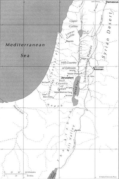
Palestine: Principal Geographic Divisions.
Egypt essentially forms part of the vast desert extending from the Atlantic Ocean across northern Africa and through the Arabian Peninsula to the Indian Ocean. But Egypt contrasts with the surrounding sands because of the river that defined it in antiquity and continues to do so today. In the famous phrase of the ancient Greek historian Herodotus, Egypt is the “gift of the Nile.” Spring rains in the African highlands south of Egypt swelled the Nile’s tributaries, causing an annual summer flooding of normally 7 to 8 meters (23 to 25 feet). The abundant water also carried silt in suspension, providing a regular overlay of fertile topsoil. The Nile was thus the lifeline of Egypt, providing water year-round and guaranteeing food production. More than any other factor it explains the extraordinary longevity, stability, and conservatism of Egyptian culture. A second-millennium
BCE
hymn to the Nile voices the blessings the river brought: “When he rises, then the land is in jubilation, then every belly is in joy, every backbone takes on laughter, and every tooth is exposed. The bringer of food, rich in provisions, creator of all good, lord of majesty, sweet of fragrance” (trans. John A. Wilson; p. 372 in James B. Pritchard, ed.,
Ancient Near Eastern Texts Relating to the Old Testament,
Princeton, N.J.: Princeton University Press, 1969).
Harnessing this annual beneficence required effort; dikes and dams, irrigation ditches and canals, and pumps of various sizes extended the watered land and made possible irrigation after the summer flood. The result was a ribbonlike oasis dramatically visible from the air today, extending some 1,200 kilometers (750 miles) from the First Cataract at Aswan to the Mediterranean. For the ancient Egyptians, this was the “black land,” a stark contrast to the “red land” of the virtually rainless desert.
The pyramid, the familiar element of Egyptian architecture, found not only in the tombs of the early dynasties but also as the top of every obelisk, is the stylized representation of the primeval mound of earth left behind by the receding Nile waters. Behind the tip of the pyramid are the rays of the sun, under various names the principal deity of the ancient Egyptians, responsible not only for agricultural production but also for the desert on both sides of the Nile.
This desert is relieved by only a few major oases. It effectively isolated Egypt from its neighbors, giving the ancient Egyptians an arrogant resistance to foreign influence and contributing to their cultural conservatism. But because neither the Nile Valley nor the desert could satisfy Egypt’s needs and desires, throughout its history Egypt launched repeated imperialistic excursions, seeking to control access to raw materials such as cedar from Lebanon and copper from Sinai, as well as agricultural commodities that Egypt’s mostly semitropical climate could not support, such as olive oil and wine.
Far to the northeast lay Mesopotamia, a region that was home to a succession of Egypt’s rivals for control of the Levant. The term
Mesopotamia
is relatively late, first attested in Greek geographers of the Hellenistic period. But it is apt, for the region “between the rivers” forms a large geographic unit. The Euphrates to the west and the Tigris to the east united the lands through which they flowed; like Egypt’s Nile, they provided water for irrigation and major avenues of transport. The Euphrates
and the Tigris, roughly 2,800 kilometers (1,740 miles) and 1,850 kilometers (1,150 miles) long, respectively, both originate in the mountains of Armenia. From there they wend their separate, slowly converging ways in a generally south-southeasterly direction through the hilly terrain of northeastern Syria and northern Iraq into the great plain of southern Iraq, until they finally meet some 160 kilometers (100 miles) northeast of the Persian Gulf at Basra.
Southern Mesopotamia was essentially a floodplain. In distant geological prehistory the two rivers flowed separately into the Persian Gulf, but alluvial deposits gradually extended the floodplain, as the ancients themselves recognized. In the very beginning,
When skies above were not yet named,
Nor earth below pronounced by name,
Apsu, the first one, their begetter
And maker Tiamat, who bore them all,
Had mixed their waters together.
(Dalley, 233)
Thus the beginning of
Enuma Elish,
the “Babylonian Creation Epic,” describes how the world began with the mingling of the waters of the rivers (the god Apsu) with those of the sea (the goddess Tiamat). From their union land emerged, and so the horizon and the sky itself, among the first of a series of births that in the epic culminates with the birth of the storm-god Marduk and his emergence as king of the gods and creator of human beings
The rivers of Mesopotamia were not, however, as benign as the Nile. They flooded unpredictably, sometimes even violently. The Euphrates especially seems to have shifted its bed repeatedly over the course of the millennia, one indication of recurrent severe flooding. Mesopotamia also had less than abundant rainfall, often insufficient for sustaining agriculture. Together these factors led to the development of irrigation by ditches and canals, which is attested before historic times.
For much of its history, Mesopotamia has been split by antagonism between the north, in later antiquity generally controlled by Assyria, and the south, or Babylonia. In the third millennium, the southern part itself was fragmented. The lower part, Sumer, gave its name to the culture of the Sumerians. The upper region of southern Mesopotamia was Akkad, originally the name of the city from which its Semitic rulers spread their control. (The general term
Akkadian
for the Semitic languages of Assyria and Babylonia derives from this name.) But despite sometimes intense rivalry, the differences between north and south were much less significant than their shared culture. Allowing for local variations, by 2000
BCE
they had the same language, the same pantheon, the same views of themselves and their place in the world. Blocked on the east by the Zagros Mountains, on the south by the Persian Gulf, and on the west by the northern expanses of the Arabian Desert, and watered by the same two rivers, they formed a natural unity whose imperialistic impulse was northward and westward—to Asia Minor and the Levant, and even at times into Egypt itself.
The Ancient Near East
The slow evolution of the human species and its gradual adaptation to and control of the environment is beyond the scope of this volume. The earliest vestiges of hominid activity in the Levant date to the early Paleolithic era well over a million years ago and, as elsewhere, consist principally of worked stone tools. Over the aeons technological sophistication very gradually increased, and sites where artifacts and occasionally human bones occur become more numerous, suggesting a growth in the number and size of the usually isolated small groups. Eventually the sites can be recognized as seasonal camps, characteristically with scatters of stone artifacts and occasionally faunal and floral remains, the tantalizingly sparse traces of small bands of hunters and gatherers. But as the climate warmed toward the end of the last Ice age, the archaeological record reveals an increasingly rapid rate of change and a concomitant increase in population. These developments seem to have occurred independently in several different regions, although even in the earliest stages there is evidence of contact, perhaps in the form of trade, between relatively widely separated groups. By the Upper Paleolithic (ca. 43,000–18,000
BCE
) and Epipaleolithic (ca. 18,000–8500
BCE
) eras, we find occasional semipermanent settlements, some with burials that have been interpreted as evidence for both social structure and religious beliefs.